|
Climatic
change and geotectonic movements have led to migration and abandonment of several rivers
and drainage systems. Some of them are ‘lost’ because of the overburden of silt.
But several evidences left by them usually help in proving the existence of a geomorphic
feature in a particular location, which attract the attention of the interested people to
discover the past. In India, the river Saraswati reflects such a fascinating history,
supported by geological, hydrological and archaeological evidences as well as the records
of the most modern tools, such as remote sensing and GIS. With the aid of remote sensing
through orbiting satellites, the mystery of the river is more or less solved. |
History
behind the mystery
The satellite imagery of Saraswati river |
Geological
record indicates that during the late Pleistocene glaciation, the water of the Himalayas
was frozen and that in the place of rivers, there were only glaciers, masses of solid ice.
When the climate became warmer, the glaciers began to break up and the frozen water held
by them surged forth in great floods, inundating the alluvial plains in front of the
mountains. The melting of glaciers has also been referred in Rig Vedic literature, in
mythological terms. It was the first interglacial period in Holocene marking the break-up
of glaciers and release of the pent-up waters that flowed out in seven mighty river
channels referred as the ‘Sapta Sindhu’ in the Rig Veda, traced from east to
west. The ‘Sapta Sindhu’ refers to the rivers Saraswati, Satadru (Sutlej),
Vipasa (Beas), Asikni (Chenab), Parosni (Ravi), Vitasta (Jhelum) and Sindhu (Indus). Among
these, the Saraswati and the Sindhu were major rivers that flowed from the mountains right
up to the sea. The hymns in praise of the Saraswati are probably some of the oldest,
composed more than 8000 years ago.
For 2000 years, between 6000 and 4000 B.C., the Saraswati flowed as a great river. R. D.
Oldham (1886) was the first geologist who argued logically pointing to the great changes
in the drainage pattern of the rivers of Punjab and western Rajasthan converting a once
fertile region into a desert. According to geological and glaciological studies, the
Saraswati was supposed to have originated in Bandapunch massif (Saraswati-Rupin glacier
confluence at Naitwar in western Garhwal).
The river, which had originated from Kapal tirith in the Himalayas in the west of Kailash,
was flowing southward to Mansarovar and then taking a turn towards west. Even today the
Saraswati flows from the south of Mana pass which meets river Alaknanda, 3 km away in the
south of Mana village. Descending through Adibadri, Bhavanipur and Balchapur in the
foothills to the plains, the river took roughly a southwesterly course, passing through
the plains of Punjab, Haryana, Rajasthan, Gujarat and finally it is believed to have
debounched into the ancient Arabian Sea at the Great Rann of Kutch. In this long journey,
the Saraswati is believed to have had three tributaries, Shatadru (Sutlej) originating
from Mount Kailas, Drishadvati from Siwalik Hills and the old Yamuna. They flowed together
along a channel, presently known as the Ghaggar River, which is known as Hakra River in
Rajasthan and Nara in Sindh. Some experts consider these two rivers as a single river
whereas others consider the upper course of the Saraswati as Ghaggar and the lower course
as the Hakra River, while some others call the Saraswati of the weak and declining stage
as the Ghaggar. |
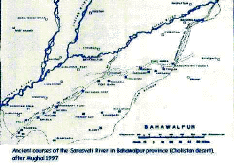
Ancient courses of Saraswati river in Bahawalpur province (Cholistan desert)
|
The
river was obliterated within a short span, in the Quarternary period of the Cenozoic era,
through a combination of destructive catastrophic events. The decline of the river appears
to have commenced between 5000 and 3000 B.C., probably precipitated by a major tectonic
event in the Siwalik Hills of Sirmur region. Geological studies reveal that the massive
landslides and avalanches were caused by destabilising tectonic events which occurred
around the beginning of Pleistocene, about 1.7 million years ago in the entire Siwalik
domain, extending from Potwar in Pakistan to Assam in India. Those disturbances, linked to
uplift of the Himalayas, continued intermittently. Presumably, one of these events must
have severed the glacier connection and cut off the supply of melt water from the glacier
to this river; as a result, the Saraswati became non-perennial and dependent on monsoon
rains. The diversion of the river water through separation of its tributaries led to the
conversion of the river as disconnected lakes and pools; ultimately it was reduced to a
dry channel bed. Therefore, the river Saraswati has not disappeared but only dried up in
some stretches. |
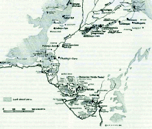
Evidences supporting
Palaeochannels
Hydrogeological evidences Lunkaransar,
Didwana and Sambhar, the Ranns of Jaisalmer, Pachpadra, etc. are a few of the notable
lakes, formed as a result of the changes; some of them are highly saline today, the only
proof to their freshwater descent being occurrences of gastropod shells in those lake
beds. Mr. Oldham accepted that there have been great changes in the hydrography of Punjab
and Sind within the recent period of geology. Wilson has mentioned about the Sotar valley
where “the soil is all rich alluvial clay such as is now being annually deposited in
the depressions which are specimens of those numerous pools which have given the Saraswati
its name, ‘The River of Pools’; and there seems little doubt that the same
action, as now goes on, has been going on for centuries”.
Archaeological evidences Most of the
archaeological sites of the-then civilisation are located on the Saraswati river basin.
There are four Harappan and pre-Harappan sites in Punjab, in addition to the sites in
Rajasthan and U.P. These sites are located at Rupar (present Ropar), Nihang Khan, Bara and
Sirsa valley. Harappan culture flourished in the western part of Punjab around 2500 B.C.
It is believed that the Harappans entered through the Indus Valley into Kalibangan valley
on the left bank of Ghaggar (erstwhile Saraswati) and spread to Punjab along the Saraswati
River. Carbon dating of the material at Kalibangan suggests that Harappan culture
flourished around 2500 B.C. in India and existed for 1000 years. So the present day
geomorphologic set up did not exist till 1500 B.C. and the Indus, the Sutlej and the Beas
followed independent courses to the sea.
Evidences from Remote Sensing and GIS A
remote sensing study of the Indian desert reveals numerous signatures of palaeochannels in
the form of curvilinear and meandering courses, which is identified by the tonal
variations. The Saraswati River could be traced through these palaeochannels as a
migratory river. Its initial course flowed close to the Aravalli ranges and the successive
six stages took west and northwesterly shifts till it coincides with the dry bed of the
Ghaggar River.
|
 It
is found that the course of the river Saraswati in the states of Punjab, Haryana and
Rajasthan is clearly highlighted in the LANDSAT imagery by the vegetation cover thriving
on the rich residual loamy soil along its earlier course. Digital enhancement studies of
IRS-1C data (1995), combined with RADAR imagery from European Remote Sensing satellites
ERS 1/2, identified subsurface features and recognised the palaeochannels beneath the
sands of the Thar Desert. A study of NRSA, based on satellite derived data, has revealed
no palaeochannel link between the Indus and the Saraswati, confirming that the two were
independent rivers; also, the three palaeochannels, south of Ambala, seen to swerve
westwards to join the ancient bed of the Ghaggar, are inferred to be the tributaries of
Saraswati/Ghaggar, and one among them, probably Drishadvati. Digital enhancement
techniques using high resolution LISS-III data of IRS-1C satellite, together with
pyramidal processing, identified two palaeochannels trending NE-SW in Jaisalmer district
of Rajasthan, which are presumed to be the lost river Saraswati. In a study, NRSA used
Indian Remote Sensing Satellite (IRS-P3) Wide Field Sensor (WiFS) data covering the Indus
river system to study the palaeodrainage in northwestern India. The image elements such as
tone, colour, texture, pattern, association of WiFS and SIR-C/X-SAR images helped to
derive information on current as well as palaeodrainage. WiFS image reveals very faint
trace of the river Saraswati/Ghaggar while in the SIR-C/X-SAR image, the connectivity of
the palaeochannel could be easily established due to the presence of dark irregular shaped
features associated with wetness. It
is found that the course of the river Saraswati in the states of Punjab, Haryana and
Rajasthan is clearly highlighted in the LANDSAT imagery by the vegetation cover thriving
on the rich residual loamy soil along its earlier course. Digital enhancement studies of
IRS-1C data (1995), combined with RADAR imagery from European Remote Sensing satellites
ERS 1/2, identified subsurface features and recognised the palaeochannels beneath the
sands of the Thar Desert. A study of NRSA, based on satellite derived data, has revealed
no palaeochannel link between the Indus and the Saraswati, confirming that the two were
independent rivers; also, the three palaeochannels, south of Ambala, seen to swerve
westwards to join the ancient bed of the Ghaggar, are inferred to be the tributaries of
Saraswati/Ghaggar, and one among them, probably Drishadvati. Digital enhancement
techniques using high resolution LISS-III data of IRS-1C satellite, together with
pyramidal processing, identified two palaeochannels trending NE-SW in Jaisalmer district
of Rajasthan, which are presumed to be the lost river Saraswati. In a study, NRSA used
Indian Remote Sensing Satellite (IRS-P3) Wide Field Sensor (WiFS) data covering the Indus
river system to study the palaeodrainage in northwestern India. The image elements such as
tone, colour, texture, pattern, association of WiFS and SIR-C/X-SAR images helped to
derive information on current as well as palaeodrainage. WiFS image reveals very faint
trace of the river Saraswati/Ghaggar while in the SIR-C/X-SAR image, the connectivity of
the palaeochannel could be easily established due to the presence of dark irregular shaped
features associated with wetness.
Missing of a prominent river from the map is not a mystery; it is quite natural as the
natural phenomena evolve through environmental changes. A part of the river Saraswati till
now exists as Ghaggar in Haryana, the rest of it has disappeared in the fringes of the
Marusthali or the Thar Desert. Bhabha Atomic Research Centre, Mumbai has made a
breakthrough in its research for the existence and probable location of the mythical
Saraswati river. The Rajasthan Ground Water Department undertook the task to
‘unearth’ the river with the collaboration of BARC and Physical Research
Laboratory, Ahmedabad (a wing of ISRO) in 1998. If the effort is successful, the people
living in the desert belt of Rajasthan will be hopefully supplied more than 3500 year old
water derived from palaeo-channels, believed to be the mythical Saraswati.
|
|
|
